Concept and objectives
Soil and land information is needed for policy-making, hands-on management of land resources, and monitoring of the environmental impact of development. Lack of comprehensive information about land resources - globally, nationally or locally - means uninformed policies, continuing degradation of land and water resources, unnecessary carbon emissions to the atmosphere, and no likelihood of achieving the United Nations Millennium Development Goals. The viability and cost of vital infrastructure is affected just as much as food and water security and response to environmental change. In the case of the European Soil Thematic Strategy, the operational measures laid down in the Framework Directive and Impact Assessment are hamstrung by lack of accessible, easy-to-use, consistent, harmonized and relevant soil data.
Present situation
The only harmonized global soil information is the FAO-Unesco Soil Map of the World at scale 1:5 million (FAO-Unesco 1974-1981); for Europe, the 1986 Soil map of the European Communities at scale 1:1 million (CEC 1985) is supported by the Soil geographical database for Eurasia and the Mediterranean (Lambert et al. 2002). A much-improved methodology for a World Soil and Terrain database (SOTER) incorporates quantitative information on both soils and terrain (van Engelen and Wen 1995). Figure 1 depicts the present status of SOTER compilation. Figure 2 illustrates the SOTER attribute data model that can contain up to 118 unique attributes of a soil and terrain unit.
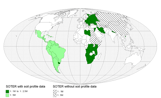
Figure 1: Status of World SOTER databases, 2008
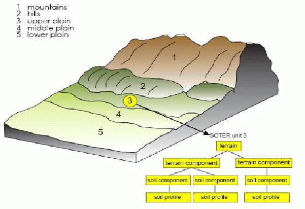
Figure 2: SOTER attribute data model
A comprehensive soil observing system consists of five components:
- data collection
- transformation
- data management
- interpretations
- delivery
At the current SOTER, these may be characterized as follows:
Data collection: Soil and terrain data have been collected by national organizations at various scales, using their own standards and methods.
Transformation: Soil survey data are converted manually to a SOTER-compatible format. Mismatches at national boundaries and data gaps are carried forwards. Attribute data are held only for complex mapping units; a further phase of data selection and interpretation is necessary to generate specific attribute data for particular places, or seamless data surfaces for individual attributes.
Data management: The database is not accessible for on-line queries.
Interpretations: Applications can be made only for limited areas and are further constrained by data gaps, lack of standardization and mismatches at national boundaries.
Delivery: The database is not providing capabilities of on-line queries.
In short, the present system cannot fulfill the requirement for immediately accessible, interoperable, digital information on specific soil and terrain attributes, and global coverage is incomplete. e-SOTER will meet the demand by developing a combination of methods and technologies that can deliver global soil and terrain data at scale 1:1 million.
European contribution to a global soil observing system
GEOSS plans a global Earth Observation System to meet the need for land resources information. Also the European Commission puts a strong focus on earth observation in various activities in DG Research. e-SOTER is proposed as the European contribution to a Global Soil Observing System, overcoming the present shortcomings of SOTER and providing a Regional Pilot Platform that can be extended worldwide.
e-SOTER adds value by:
- using remotely-sensed data both to validate and correct existing survey data
- generating new data surfaces
- improving the quality of results of applications previously based on legacy data alone
- providing a freely accessible web service that delivers both selected data in an easy-to-use format and procedures to compile e-SOTER databases locally and upload these data to the European database if they meet prescribed quality standards.
The project addresses four major barriers to a comprehensive soil observing system:
- Morphometric descriptions - enabling quantitative mapping of landforms as opposed to crude slope categories. This will build upon EU- initiated DEM landform classification procedures (Dobos et al. 2005);
- Soil parent material characterization and pattern recognition by remote sensing - enabling separation of soil processes within the landscape;
- Soil pattern recognition by remote sensing;
- Standardization of methods and measures of soil attributes to convert legacy data already held in the European Geographical Soil Database and various national databases to a common standard - so that they may be applied, e.g. in predictive and descriptive models of soil behavior.
The project objectives that contribute to the lifting of the four major barriers described above are:
- Morphometric descriptions of the landforms both in an enhanced SOTER DEM methodology as well in newly developed DEM analysis using natural breaks. The existing DEM that will form the basis for the morphometric analysis will be filtered and enhanced to obtain an artifact-free product. The end product will be a landform layer in the 1:1 million scale window and 1:250 000 scale pilot areas.
- Soil parent material characterization using remote sensing and legacy data will generate a parent material classification relevant for soil development, and parent material pattern within the window and pilot areas.
- Soil pattern recognition will use existing data and converting these into a standardized SOTER format. Remote sensing will generate additional predictors of soil properties. End products will be a soil layer in the window and pilot areas with standardized soil attributes.
Additional project objectives will be:
- Quality assessment of e-SOTER. This will be achieved by a validation and uncertainty analysis.
- Applications of the newly acquired e-SOTER in the field of major soil threats and comparisons with applications based on earlier datasets.
- Dissemination of the results of the project through stake-holder conferences and through web-based services.
The end product will be a regional pilot platform with methodologies, concepts and applications that, together, will facilitate:
- An enhanced SOTER database methodology at scale 1:1 million for Europe and the world;
- Ways of generating finer-scale maps of specific soil and terrain attributes, and digital data, based on legacy soil survey data and remote sensing;
- A framework for new, cost-effective field survey and monitoring programs.
Methodology and work plan
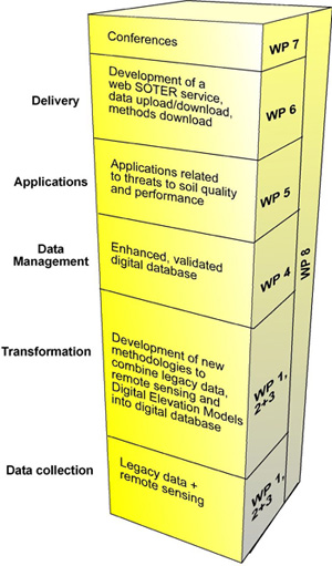
We will organize the research in a sequence of data collection, transformation, data management, interpretations and delivery. Under transformation there are two parallel thrusts that differ in scale, methodology and tools:
- Improvement of the current SOTER methodology at scale 1:1 million;
- Developing advanced methodologies at scale 1:250 000.
Activities
- Data collection: we will harmonise heterogeneous pre-existing data, based on transfer rules developed in earlier or ongoing projects like ENVASSO (FP6), and the acquisition of up-to-date remote sensing data.
- Transformation:
- We will use a combination of remote sensing and existing data to create an enhanced SOTER in four, selected windows at scale 1:1 million: two in European consortium partner countries and, also, two in International Cooperation Partner Countries – Morocco and China. In each window will have a complete SOTER coverage.
- We will explore all possible approaches in remote sensing to contribute to a much-enhanced view of soils. Within the already-defined windows, four pilot areas at scale 1:250 000 are selected according to the availability of advanced remote sensing imagery and substantial legacy data on parent materials and soils.
- Data management: Methods, concepts and technologies developed under Data Collection and Transformation will be validated and uncertainty propagation will be analyzed.
- Interpretations: We will produce various applications of the e-SOTER database relevant to the EU Soil Thematic Strategy. This will demonstrate the improvement of the e-SOTER database relative to existing databases.
- Delivery: We will generate a webservice that will dessiminate materials and methods of e-SOTER. The service will act as a contribution to a global soil observation system. The new system will be launched at two stakeholder-conferences.